


Stream edge natural communities occur along streams and rivers, where frequent flooding deposits sediment or erodes the land along the channel.
Stream edge communities, unlike other streamside and lowland habitats, are influenced and defined by these three factors:
- The velocity of flood waters affects the vegetation directly and forcefully. The high impact of water flow makes stream edges, especially sandbars and gravel washes, some of the most unstable of all natural communities.
- The substrates don’t develop well-defined soil profiles, because flooding keeps depositing new mud, silt, sand, gravel, boulders, logs, leaves, and so on, constantly shifting the substrates.
- Stream edge communities constitute a linear boundary along streams, so that when you include both sides of the stream edge, plus the stream itself, there is a corridor, a relatively open gap, through an otherwise wooded or heavily vegetated landscape. Many animals use stream edge communities as passages for travel.
A single major flooding event can reshape, reorganize, and relocate the components of a stream edge community. A big flood can wash away sandbars and gravel washes and rebuild them elsewhere; it can reroute a stream’s channel through the landscape; and it can sweep away vegetation while creating new places for plants to take root. One thing stays the same, however: the various stream edge and bottomland communities always occur somewhere along the stream and its floodplain.
There is a predictable progression of habitat types as you travel away from a stream and gradually move on to higher ground. First, there is the stream itself; then the stream edge, gravel bar or wash, steep streambank, riverfront forest, and mesic bottomland forest (which occurs on natural levees), then, continuing away from the stream, you descend slightly again to wet-mesic bottomland forest and wet bottomland forest (both of which can occur in complex mosaics, especially along the larger rivers of northern Missouri and in the Bootheel).
Riparian Areas
Here’s a term you should know: Riparian. To call something “riparian” means that it is associated with the banks or with the entire active floodplain of a river or stream. The riparian zone is a fairly broad conception of streamside habitats. It is where land and aquatic habitats join. Stream edge habitats are included within any definition of a riparian zone.
Riparian areas include stream edge communities, but they can also include all or parts of other habitats along streams, including bottomland prairies, bottomland woodlands, bottomland flatwoods, bottomland forests, and riverfront forests.
In riparian areas, the soils are relatively moist or wet, compared to the rest of the landscape, so plants that grow in riparian areas are adapted to moist or wet soils and to some degree of flooding. Riparian vegetation is typically lush and wooded, compared to nearby land. The relatively lush vegetation supports a relatively high concentration of insects and other small animals. Many larger animals, from birds to raccoons to deer, are drawn to riparian zones for water, food, and shelter. Birders know to visit riparian areas during spring and fall, because many, many migrating birds are drawn to streamsides.
Variety in Stream Edge Communities
Stream edges, like most other land habitats, have different characteristics depending on factors such as rock and soil types, geologic history, whether the area was glaciated or not, the amount and types of vegetation nearby, and so on. Because stream edges represent a meeting point between land and water, they are also influenced by aquatic factors, such as the amount and duration of flooding, the velocity of water and flood flow, stream gradients, and their position in relation to the stream’s entire course (for example, located at the headwaters, or along the larger downstream sections).
Botanists have pointed out that separate stream systems often have their own distinctive suites of stream-edge plants occurring on their gravel washes, sandbars, and stream- and riverbanks. This is similar to the phenomenon where separate stream systems host their own unique species of fish, crayfish, and other aquatic animals, which cannot travel overland to colonize nearby stream systems. Stream edge plants have the same situation, as streams are divided by woods or grassland habitats in which they cannot survive, even though another stream system might only be on the other side of a ridge.
In Missouri, regional geography plays a major role in the character of stream edge communities.
-
The low-gradient rivers in glaciated northern Missouri and in the Bootheel lowlands create stream edges with plenty of sandbar natural communities. This occurs, for example, along the large Missouri, Grand, and Mississippi rivers. The smaller streams in these regions historically meandered across their wide, fairly flat floodplains; these streams build up gradually sloping sandbars on the insides of their curves, and they cut steep-sloping banks on the outsides of the curves (as well as in straight runs).
- In the Ozarks of southern Missouri, rivers and streams have cut their channels down through ancient bedrock, creating gravel bars, rocky bluff-lined streambanks, and breathtaking vertical cliff faces. The gradients are higher in these streams, so the flow velocity is higher. There is little sand along these streams; instead, rock, cobble, and gravel line their edges. The gravel bars along clear, spring-fed Ozark streams are beloved by canoeists, swimmers, and campers.
Missouri's Three Types of Edge Communities
Missouri has three types of stream edge natural communities: sandbar, gravel wash, and streambank and riverbank.
1. Sandbars
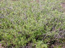
Sandbars in Missouri mostly occur in the glaciated northern half of the state, along the Missouri and Mississippi rivers, and in the Mississippi lowlands in the Bootheel. Where sandbars have recently formed, little vegetation exits, but older sandbars may have up to 60 percent ground cover. Most of the vegetation is annual wildflowers (forbs) and grasses. The shrubs are usually willows. Trees are usually absent, although scattered groups of seedlings may occur.
2. Gravel Washes
Gravel washes in Missouri mostly occur in the Ozark Highlands and parts of the Osage Plains. Unlike the sandbars in northern Missouri, gravel washes are much less likely to change position along the river, since the cliffs, bedrock outcrops, and large tracts of nearby forest provide fairly permanent obstacles that cause gravel, cobble, and other materials to keep being deposited in the same places.
As with sandbars, sections of gravel washes that were recently formed have very sparse vegetation, while undisturbed sections (gravel bar terraces) can have plenty of shrubs, wildflowers and other forbs, and grasses. In places on gravel bars where trees and shrubs become so established that they hold the substrates in place, they become riverfront forests.
Three subtypes of gravel wash communities have been identified for Missouri:
- Witch hazel/swamp dogwood/ninebark subtype: boulder, gravel, and bedrock washes on relatively small, high-gradient, often intermittent streams.
- Willow/water willow subtype: gravel bars along relatively large, permanent streams and rivers. Dense patches of water willow stabilize gravel at the edge of the stream.
- Blue beech upland waterway subtype: the primary headwater zones of larger streams and rivers, including intermittent streams, valley washes, and ravines. There is not a well-defined channel or watercourse, but waterborne sand, gravel, and other materials collect at the bases of ravines, and distinctive plants grow there: blue beech, ninebark, swamp dogwood, and great Indian plantain.
3. Streambanks and Riverbanks
Streambanks and riverbanks comprise the sloping to steep banks of the floodplain, just above the water surface or above the surface of a gravel wash along a river or stream. Where a stream curves, this community forms on the outside of the curve, while alluvial (river-borne) materials accumulate on the inside of the curve. Streambanks and riverbanks are frequently flooded, and they can remain underwater for a few hours (in upstream, headwater locations) or for weeks (along large rivers).
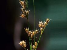
Plants on stream- and riverbanks can be located on the sloping embankments, on the overflow borders, or at the base of adjoining talus slopes or bluffs. In forested regions, trees dominate, while stream- and riverbanks in prairie and savanna areas have scattered, trees, shrubs, and grasses. Headwater locations typically are tree-lined (grass-lined in prairies).
Downstream, larger rivers are lined with zones, starting with shrubs and nonwoody plants closest to the stream, and with vines and trees on the higher ground and natural levees, farther from the water. If the substrates are stable enough, these trees often lean outward toward the water. High-velocity flooding often undercuts trees and other plants, uprooting and washing away many, exposing the roots of others.
Stream- and riverbanks occur throughout Missouri. Because the geology, landforms, water flow patterns, and other factors vary by region — and influence the character of stream- and riverbanks — these streamside communities are divided into four subtypes based on region.
- The Glaciated Plains/Big Rivers subtype is associated with the broad floodplains of large, meandering streams and rivers of glaciated northern Missouri and the unglaciated Osage Plains of western Missouri. Over time, as the stream and river channels shift their paths across the floodplain, they often create natural levees on which forests eventually develop. On the opposite bank, where the stream deposits sand, silt, clay, and other materials, new land gradually develops. As this new land grows toward the streambank, a predictable succession of plants colonizes it: first annual, then perennial grasses and sedges, followed by shrubs and then trees.
-
The Prairie Headwater Stream subtype is specifically associated with true prairies, which in our state almost always occur in the plains of northern and western Missouri. This stream edge subtype begins in the shallow valleys of prairies, at the point where drainage bordered by swales starts to develop entrenched gullies and then true waterways. These stream edges are some of the few places on native prairies where woody plants may survive, as the extra moisture along stream edges affords protection from the effects of fire. Characteristic plants include false indigo, buttonbush, swamp dogwood, and grasses and forbs associated with prairie wetlands.
- The Ozark subtype is associated with entrenched streams and rivers as they wind across their narrow floodplain on stable bedrock, bending when they encounter steep rocky bluffs and cliffs. Where the river bends, the inside curve contains floodplain materials deposited by the stream. In open, sunlit places, bedrock streambanks contain a variety of grasses, sedges, and other nonwoody plants, plus shrubs. Shaded bedrock areas have more shrubs, ferns, and mosses. Another variation occurs in the St. Francois Knobs and Basins and nearby igneous-rock areas; here, the streams are bordered by igneous talus or sandy terraces, which are stabilized by mats of shrubs and nonwoody plants. Common alder, winterberry, and royal fern are some of the plants especially associated with these igneous stream- and riverbank communities.
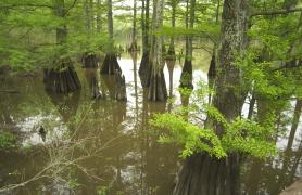
- The Lowlands subtype comprises streambanks along the sluggish streams and rivers in Missouri’s Bootheel lowlands. Many of the plants characteristic in this subtype are usually associated with the southern coastal plain (that is, in states south and southeast of Missouri): bald cypress, willow oak, red maple (Drummond’s maple variety), water elm, Virginia willow, swamp rose, water willow, and lizard’s tail.
Stream Edge Animals
The fact that stream edges represent an intersection of different habitats makes them attractive to many types of animals. Stream edges are open areas next to woods; they are a source of water; and they support lush plant life and an abundance of aquatic, terrestrial, and flying insects.
Stream edges are home to animals that specialize in this habitat, but they also attract many animals that come for foraging or nesting opportunities. These animals have more generalized habitat requirements and are not restricted to the stream edge habitat.
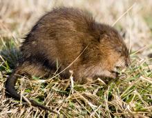
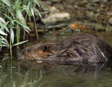
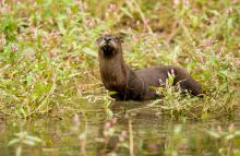
- Mammals that are strongly associated with stream edge habitats include river otter and muskrat. Raccoons are often seen on gravel washes.
-
Many birds are attracted to stream edges, especially migratory songbirds. The endangered interior least tern and piping plover are restricted to sandbar communities. They nest on Mississippi River sandbars — islands in the middle of the river where they are safe from land-based predators. The spotted sandpiper is also strongly associated with sandbars.
- Other vertebrate animals include Fowler’s toad and the northern cricket frog, which are both strongly associated with sandbars. Watersnakes are common along gravel washes.
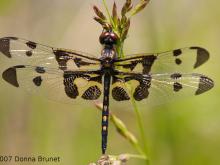
- Many species of dragonflies and damselflies cruise up and down the open corridor along streams, hunting insects that are likewise attracted to the streamside habitat.
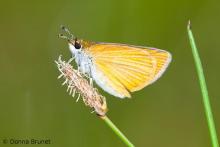
- Many species of butterflies, including swallowtails, sulfurs, blues, and skippers, are attracted to stream edges where they “puddle” on wet sand or gravel to obtain fluids and salts.
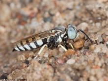
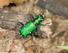
- Many other insects are especially attracted to sandy areas, including sand wasps, colletid and mining bees, tiger beetles, grouse locusts, and antlions.
- Along gravel washes, the southern pearly eye butterfly and toad bugs are common.
- Many types of insects are aquatic in their juvenile stages, then become terrestrial adults upon their final molt; the stream edge community is typically where this happens. The adults of these insects usually meet and mate near the stream where the female will deposit their eggs.
Streambanks and riverbanks have their own suite of common or characteristic animals:
-
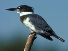
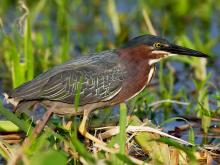
Birds. Belted kingfishers build their nest burrows in the side of streambanks. Other birds that nest along streambanks are yellow-crowned night-heron, green heron, bank swallow, and northern rough-winged swallow. The Louisiana waterthrush forages along streambanks for aquatic invertebrates.
-
Reptiles. Softshell turtles often bury their eggs in nests on sandy banks.
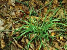
- Invertebrates. Tiger beetles hunt on sandy streambanks. Several uncommon butterflies are highly associated with stands of wild cane along streams in the lower Ozarks. Devil crayfish dig burrows with mud chimneys along streambanks. Grouse locusts, a group of small grasshoppers, live on sandy riverbanks; look for them on sunny days in late winter.


Key species


Related Habitats
Cliffs

Talus

Big Rivers

Grassland and Prairie Streams

Mississippi Lowland Streams
Ozark Streams

Roadsides, Industrial Sites, Mining Areas
