


Windy Bar Island Conservation Area is extensively forested, with approximately 90 percent of the island chain composed of riverfront forest or wet-mesic bottomland forest natural communities.
Media
Scientific Name
Graptemys pseudogeographica pseudogeographica
Family
Emydidae (basking, marsh, and box turtles) in the order Testudines (turtles)
Description
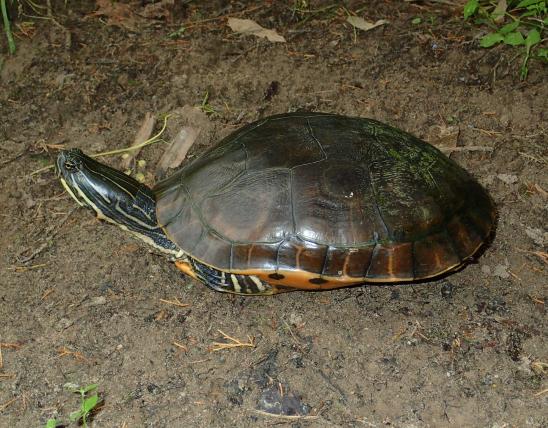
Missouri has two subspecies of false map turtle (Graptemys pseudogeographica): the northern false map turtle (G. p. pseudogeographica) and the Mississippi map turtle (G. p. kohnii). Where the two species occur together in eastern Missouri, especially along the Mississippi, it can be difficult to tell the subspecies apart.
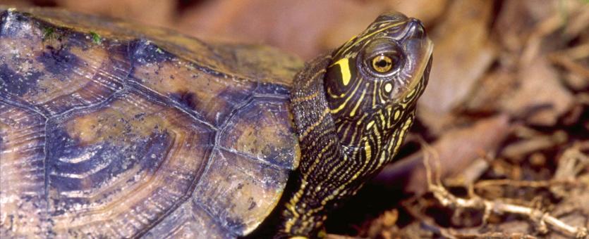
The northern false map turtle (G. p. pseudogeographica) occurs in the Missouri River in central and northwestern Missouri and the upper Mississippi River. It is a medium-sized species with a prominent keel along the center of the upper shell and thin yellow lines on the head, neck, and limbs. The carapace (upper shell) is brown or olive, with light lines that follow the contour of each small, dark blotch on the marginal and costal scutes (the scales along the edge and sides of the shell). The keel running along the top of the shell is usually high and forms a low ridge at the rear edge of each vertebral (midline) scute. The rear of the carapace is strongly serrated (jagged or saw-toothed). The plastron (lower shell) is flat and plain yellow, but it may have dark lines or smudges along the scute (scale) seams, especially on young turtles. Its exposed skin is brown or olive with numerous narrow yellow lines. The eye color is usually white or light yellow; in this subspecies, there may or may not be a dark, horizontal line crossing the pupil. A yellow marking behind each eye extends upward and then backward, approximately forming a right angle or “L” shape. However, these yellow markings can vary among individuals. Up to 3 thin, yellow neck lines reach each eye. There is a small, round or oblong, yellow spot below each eye and at the forward tip of the chin.
The Mississippi map turtle subspecies (G. p. kohnii) occurs mainly in the lower Mississippi River, southern Ozark rivers, and southwestern Missouri. It is similar to the northern map turtle, and there is overlap in characteristics in eastern and southeastern Missouri populations. To distinguish between them, first note the shape of the yellow mark behind each eye. The northern false map turtle has an “L” yellow mark and narrow, yellow lines touching the posterior of each eye. Mississippi map turtles have a crescent-shaped line behind each eye, and the yellow lines do not touch the posterior edge of each eye. Additionally, specimens of the Mississippi map turtle from eastern and southeastern Missouri rivers tend to have eyes that lack a horizontal black line across the eye on each side of the pupil.
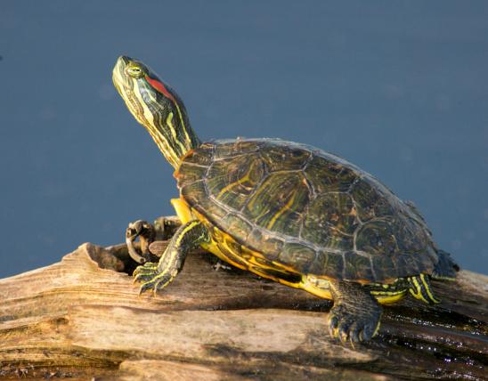
Similar species: To identify our three map turtle species, look at the yellow markings near the eye. Ouachita map turtles (G. ouachitensis) have a large, wide yellow mark behind each eye that is widest just behind the eye and becomes narrow on top of the head. Northern map turtles (G. geographica) have a small yellow marking behind each eye that usually has a slight projection that is oriented toward the neck.
Size
Adult upper shell length: 6 to 10½ inches (females); 3½ to 6 inches (males).
Where To Find

Broadly speaking, this species is primarily found in the Missouri and Mississippi rivers and larger tributaries. The northern false map turtle subspecies occurs in the Missouri River in central and northwestern Missouri and the upper Mississippi River. The Mississippi map turtle subspecies occurs mainly in the lower Mississippi River, southern Ozark rivers, and southwestern Missouri. The ranges overlap in southeastern, eastern, and northeastern Missouri, and some turtles have characteristics of both subspecies.
Habitat and Conservation
Large rivers and their backwaters are the preferred aquatic habitat for northern false map turtles. The species also occurs in river sloughs, oxbow lakes, lakes, and reservoirs.
On the Mississippi River in southeastern Missouri, northern false map turtles particularly prefer the main channel of the river, especially around wing dikes. A muddy bottom, some aquatic vegetation, and numerous basking sites are important requirements.
A four-year study of the habitat selection of this species was conducted along a section of the Missouri River, in central Missouri's Cooper County. The study gleaned the following information. Major flooding along the Missouri River in 1993 and 1995 altered the floodplain and increased the availability of various wetlands to semi-aquatic turtles. These wetlands included flooded agricultural fields, flooded woodlands, and scour ponds — the formation of new and often permanent pools away from the main river channel. Female northern false map turtles used the main river channel more often, while males used the more permanent scour ponds. Hatchlings and young adults used shallow and temporary wetlands. These sites provided more available food and fewer predators. In addition, this and other studies found that unnatural winter lowering of water levels of floodplain wetlands will kill overwintering young northern false map turtles and other species. These water bodies were disconnected from the main channel, and the dormant turtles were killed by freezing.
Overwinter dormancy takes place in the mud at the bottom of sloughs, lakes, and backwater areas of rivers. In the southern third of Missouri, these turtles may become semiactive during a mild winter. It is likely they do not eat any prey during winter months.
A study of Mississippi River turtles in southeastern Missouri found that false map turtles made up 82 percent of the turtles out of a total of six species that were captured in fyke and trammel nets.
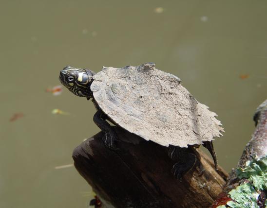
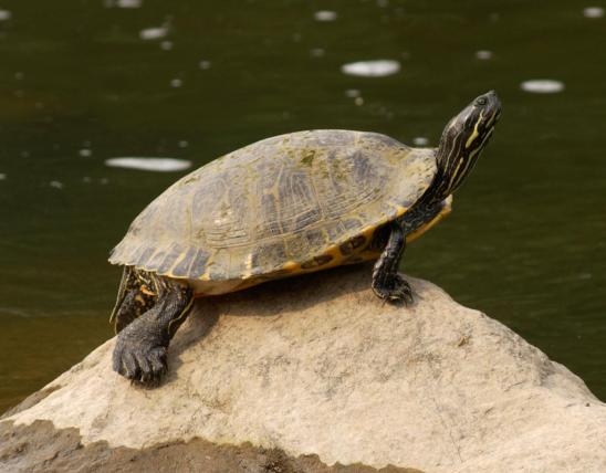
Basking behavior of this species is similar to other map turtles. Much of the day may be spent basking on protruding logs or rocks, especially those objects that are along the shore. They are easily disturbed while basking, and the passing of a boat will cause a quick dash into the water. If there is no additional disturbance, the turtles will swim back and climb back onto a basking object within 10 minutes or less. A typical basking stance of this species is to stretch out the head and neck, as well as all limbs, as far as they can and remain in this pose for minutes or hours.
Food
Feeding takes place in early morning. Northern false map turtles eat a variety of prey including snails, crayfish, aquatic insect larvae, dead fish, and aquatic vegetation.
False map turtles and other species of aquatic turtles have been observed feasting on 13-year periodical cicadas (Magicicada spp.) as they drop into the waters of the Lake of the Ozarks.
Status
Although false map turtles are the most common turtle species encountered in the Missouri and Mississippi rivers, changes in riverine habitat, historical collecting, and drowning in fishing gear have likely affected this species. Habitat alteration and loss are important negative factors when trying to protect false map turtles in Missouri.
Life Cycle
Life Cycle
Courtship and breeding take place in the water, usually in the spring, with most breeding activity occurring in April through May. There have been reports of false map turtles breeding in the fall.
Soon after mating, females begin swimming to the general area of nesting sites, such as islands with sandy beaches, the edges of agriculture fields, and open areas with loose soil and little vegetation. When ready to nest, they will move onto land and search for a suitable site. In stable aquatic habitats, females will use the same nesting locations year after year.
Nesting begins in early June and lasts through July. A female uses her hind limbs to dig a flask-shaped hole about 3½ to 6 inches deep for egg laying. Northern false map turtles may lay 8–22 eggs per clutch, averaging 14 eggs. Mississippi map turtles are reported to lay considerably fewer eggs (2–8 eggs per female). In Tennessee, this species is reported to lay up to 4 clutches of eggs per season.
The eggs generally hatch in late summer or early autumn after an incubation period of about 2 months. Males generally mature in 4–6 years; females in 8–12. Individuals have been known to live for up to 30 and 35 years.
Human Connections
In Missouri, false map turtle populations may be damaged by habitat alteration and loss. Natural resource agencies need to restore and protect rivers by improving water quality and retaining natural flow. These efforts are critical when a species is having a difficult time maintaining a sustainable population.
Map turtles, when young, are sometimes kept as pets. Conservationists in Europe are concerned that U.S.-exported aquatic turtles, if released into the wild, may become invasive in their waters.
Ecosystem Connections
As predators, map turtles help control the populations of the animals they consume. Map turtles are also a prey species, despite their shells. Eggs and hatchlings, in particular, can become easy prey for a raccoon, snake, heron, or other predatory animal large enough to swallow them.
Close to 90 percent of the nests of this species are destroyed by predators within 24 hours after its eggs are laid. Raccoons, river otters, skunks, and red foxes are the primary turtle nest predators. Also, a fly species was discovered laying eggs in map turtle eggs right when the young turtles began hatching. The fly maggots ate the exposed egg yolk, then entered the young turtles’ belly; up to 36 percent of the hatchlings were killed before they could leave the nest.
A study of northern false map turtles in western Wisconsin observed common grackles landing on basking map turtles to search for and eat leeches that were attached to the turtles’ skin. The turtles paid little attention to this behavior and tolerated the pulling and pecking.
The false map turtles are in family Emydidae (the pond and box turtle family). This is one of the largest families of living turtles in the world. It comprises 12 genera, containing 52 species. In general, turtles in this family are small to medium sized and are adapted to a variety of habitats. This family includes several colorful species. Although the majority of species are aquatic (such as the eastern river cooter), several kinds are either semiaquatic or have taken to life on land (for example, the box turtles). In Missouri, this family is represented by 7 genera with a total of 11 species and 1 additional subspecies.
Title
Media Gallery
Image

Credit
MDC Staff
Right to Use
Photo by MDC Staff, courtesy Missouri Department of Conservation
Image

Title
Similar Species
Similar Species
Media
Media
Media

Media
Media
Media
Media
Media
Where to See Species
About Reptiles and Amphibians in Missouri
Missouri’s herptiles comprise 43 amphibians and 75 reptiles. Amphibians, including salamanders, toads, and frogs, are vertebrate animals that spend at least part of their life cycle in water. They usually have moist skin, lack scales or claws, and are ectothermal (cold-blooded), so they do not produce their own body heat the way birds and mammals do. Reptiles, including turtles, lizards, and snakes, are also vertebrates, and most are ectothermal, but unlike amphibians, reptiles have dry skin with scales, the ones with legs have claws, and they do not have to live part of their lives in water.