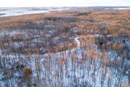
Holly Ridge Conservation Area
Multiuse trails inside a multiuse area
While more than 7 miles of trails in Holly Ridge Conservation Area (CA) are classified as “multiuse,” meaning that bicycling, horseback riding, and hiking are allowed, the term could be used generally for the entire area.
In addition to the multiuse trails, the 1,000-acre conservation area, located northeast of Dexter in southeast Missouri’s Stoddard County, also boasts additional hiking-only trails, two natural areas, an archery range, and two fishing ponds, providing plenty of opportunity for those wanting to beat the winter blahs with some outdoor fun.
Holly Ridge CA sits atop Crowley’s Ridge, a geographic formation that rises to 250 feet above the surrounding Mississippi River lowlands. From its position on the edge of Crowley’s Ridge, the area offers panoramic views of the Bootheel flatlands to the east.
The area is home to both Beech Springs and Holly Ridge natural areas. Between the two, visitors can experience forests more likely to be found in Arkansas and Tennessee than in the nearby Ozarks. Keen-eyed visitors will also spot seeps and rare plants, including the American holly that inspired the area’s name.
If one is seeking more than views, Holly Ridge CA also hosts a static archery range with 10-, 20-, 30-, and 40-yard targets, and a broadhead target.


Also In This Issue

Serving Nature and You: Fiscal Year 2022
And More...
This Issue's Staff
Editor - Angie Daly Morfeld
Associate Editor - Larry Archer
Photography Editor - Cliff White
Staff Writer - Kristie Hilgedick
Staff Writer - Joe Jerek
Staff Writer – Dianne Van Dien
Designer - Shawn Carey
Designer - Marci Porter
Photographer - Noppadol Paothong
Photographer - David Stonner
Circulation - Laura Scheuler


