


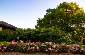
Missourians are privileged to have a large number of public areas in which to relax and enjoy nature. Designated natural areas are of particular importance and value to us because they showcase some of the best examples of our state’s original landscape. You can visit these places and see rare plants, animals, and geological features that appear as they did in pre-settlement days. Native tallgrass prairie ripples across the loess hills of northwest Missouri and caves, springs, and sinkholes harbor natural treasures in the Ozarks. Wetlands and deep rich woodlands dot the central part of the state, and a mosaic of rare plants and animals spreads across the landscape.
Natural areas represent the very best of the natural world our great state has to offer. The designation and protection afforded to natural areas, whether on a conservation area, state park, or foundation trust, preserves something of great scientific and educational value for us and future generations.
This selection of photos represents some natural areas that are particularly hard to reach. Perhaps these are areas you have not yet visited or even heard of. They can take a bit of planning to get to, and they don’t get a lot of coverage or visitors. These are not necessarily the most beautiful spots in the state in terms of grand vistas, but be assured that they all have something to offer if you are willing to take on the challenges of getting to them.
Some areas, like Westport Island, Horton Bottoms, and Dripping Spring, are accessible only by boat, and then only at certain times of the year due to river levels and spring flooding. Brickyard Hill and Star School Prairie are located right next to a major interstate but involve driving over 100 miles north of Kansas City to the edge of the state.
And then you have to hike for a few miles through deep woods or steep hills to get to the good stuff. Pelican Island Natural Area is so close to St. Louis’ Lambert Airport that taking aerial photos is a challenge due to airspace restrictions.
If you want to reach it, you have to be willing to paddle across a swift chute of the Missouri River. If you have ever visited the MDC boat ramp at Sioux Passage Park, you were staring at Pelican Island and may not have even known it was hiding in plain sight.
Some natural areas allow hunting (check the area regulations), so be aware of that if you are out in the wilds during turkey or deer season. Most of these places have no maintained hiking trails and only a cursory map and vague area description, so you will find yourself with a lot of bushwhacking and dead reckoning to do. The 6,000-acre Sunklands Natural Area (within the 40,000-acre Sunklands Conservation Area) is a particular challenge in this regard. I recommend that you access it with a four-wheel drive vehicle via the old logging roads. Or be prepared to park when your car has had enough abuse, and then hike for several miles.
Throw a kayak or canoe on top of the car. Grab your daypack and some water, print out a topographic map, charge the GPS, and lace up your hiking boots. Oh, and don’t forget the bug spray — lots of it. Two things are certain: You will find solitude in these places and experience nature on a different scale, large and small. This is as wild as it gets in the state of Missouri.
- Sunklands Sinkholes like this one at Sunklands Conservation Area are formed from collapsed caves that leave a depression in the ground. One sinkhole on the area is a mile long, 200 feet deep, and 600 feet across. There are many wildflower covered glades and wetland bogs like Yuccapin Basin to explore on the area as well.
- Horton Bottoms Horton Bottoms is beautiful, but remote. You can get there by motorized johnboat from the Marmaton River at Four Rivers Conservation Area. Or you can get there by canoe using the Cephas Ford Access on the Marmaton River. Once you arrive, it is worth the effort. The bottomland woodlands are lush and thick and have openings of wet prairies of cordgrass and marshes of river bulrush. Wildlife abound on the natural area with hunting and fishing permitted. No mapped trails, though. This is map-and-compass territory.
- Dripping Springs The fabulous bluff views along the Big Piney River at MDC’s Baptist Camp Access are only the start of the journey to Dripping Springs Natural Area. Put in your canoe or kayak and float downstream 1.5 miles to the natural area where you can enjoy cold spring water cascading down the sandstone bluff. Bring a fishing rod to angle for smallmouth and goggle-eye and spot some bluestripe darters and Missouri saddled darters. Finish the day with another 6.5 miles of paddling to Dog Bluff Access.
- Jack’s Fork This 3-mile stretch of the Jacks Fork River is not to be missed. Forty native fish species ply the waters of this small Ozark stream, and don’t forget binoculars for the bird-watching. With over 450 native plant species on the area, it is also home to several glacial relics, such as harebell, that were growing in the area 12,000 years ago. One of the most spectacular features of the area is Jam Up Cave with an arched opening 80 feet wide and 100 feet tall. Put in at Buck Hollow Access and float4.5 miles to Jam Up, then another 1.5 miles to Rymers River Access, or keep on floating to Eminence.
- Brickyard Hill Loess Mound These hills and bluffs are formed of “loess,” which is silt deposited by glacial meltwaters in vast mudflats thousands of years ago. Strong winds blew these silt particles into northwest Missouri where they accumulated up to 70 feet deep in places. Mostly heavily forested with very steep contour lines, the area has openings of prairie with ancient oaks along the edges, some dating prior to the Revolutionary War. Bring the tick spray and a map and compass. This would be beautiful in autumn or when the trees are bare to take in views of the Missouri River Valley along the western flank of the natural area.
- Westport Island This 480-acre natural area sits in the middle of the Mississippi River upstream from St. Louis and is accessible only by boat. Put in at Hamburg Ferry Access and boat downstream about 4 miles. Part of the Upper Mississippi Conservation Area, Westport Island is covered in mature bottomland hardwood forest, with some of the canopy reaching 100 feet high. The area is dissected by numerous sloughs and marshy wetlands that are heavily used by waterfowl during migration periods.
- Star School Hill Prairie Star School Hill Prairie is another gem composed of steep loess bluffs in northwest Missouri. It is situated high above Interstate 29, 125 miles north of Kansas City, and has commanding views of the Missouri River valley to the west. Lewis and Clark stopped here on their expedition, and the mixed grass prairie remains to this day. Steep slopes, dry soil, and westerly exposure make this an arid ecosystem with plants that are more common to central Nebraska, such as soapweed yucca, hairy grama grass, nine-anther prairie clover, skeleton plant, locoweed, dotted blazing star, and large-flowered beardtongue.
- Pelican Island This 2,100-acre natural area is considered to be the best remaining example of a mature floodplain forest in Missouri. You can only get to it by boat, and I chose to circumnavigate it by putting in a kayak at Sioux Passage Park and paddling up the Car of Commerce Chute. The chute is an important area for big river fish, such as channel catfish and flathead catfish, and I spent a lot of time walking the sandbars looking for arrowheads and beach glass. Portage over the rocky stretch of rapids and head down the Missouri River to get back to the boat launch. I saw a tremendous number of birds and deer from the kayak.


Also In This Issue
And More...
This Issue's Staff
Associate Editor - Bonnie Chasteen
Staff Writer - Larry Archer
Staff Writer - Heather Feeler
Staff Writer - Kristie Hilgedick
Staff Writer - Joe Jerek
Creative Director - Stephanie Thurber
Art Director - Cliff White
Designer - Les Fortenberry
Designer - Marci Porter
Photographer - Noppadol Paothong
Photographer - David Stonner
Circulation - Laura Scheuler