


Points of Interest:
- Hike over hills and hollows more reminiscent of the Ozarks than the prairie plains just to the west.
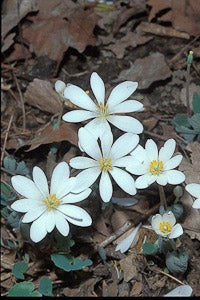
- Look for a wide variety of spring wildflowers.
- Cast your line into the North River for sunfish and channel catfish.
Natural Features Description:
One of the first Conservation Department natural areas designated (1971), this area features forests on north facing slopes with many spring wildflowers including bellwort, trout lily, wild ginger, bloodroot, wild geranium and white baneberry. On rocky woodlands of south facing slopes you might find yellow star grass, shooting star and wild hyacinth. A few years ago, Conservation Department staff noticed that the white oak dominated woodlands on the ridges had a dearth of oak seedlings or saplings beneath them. Instead a thick layer of ironwood and sugar maple had encroached in the absence of fires. Historically the broad flat ridges to the northwest of the area were covered by prairie. That meant that fires would have crept down the ridges of the natural area and kept enough sunlight on the ground for oaks to germinate and grow into the overstory. To ensure that oaks remain a component of the area, Conservation Department staff conducted thinning of select overstory trees and much of the mid-story to facilitate the regeneration and recruitment of oak. Periodic prescribed fires are planned to further this process.
This natural area is within Elmslie Memorial Conservation Area. From Palmyra head west on Highway 168 to Highway C. Take Highway C west. Just over a mile west of the intersection of Highway C with Highway Z to the south, turn off Highway C on to gravel county road 276. Head west on CR 276 for under a half mile and then turn left (south) on to CR 229. Take CR 229 south down the hill for about a mile to the parking lot (just before the bridge over the North River). The natural area begins just to the west of the parking lot. A map and compass are recommended to explore this area. Hunting and fishing are permitted.
MO
United States